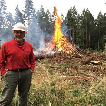
Max Bennett and Marty Main
There is a growing interest in the use of prescribed underburning in western forests to reduce fuels and fire risk and to achieve ecological objectives.
However, prescribed underburning on small, private woodlands in the region is uncommon due to liability concerns, lack of experience, and logistical challenges. Also, fire has been seen historically as undesirable, so making a shift to greater use of fire requires cultural change.
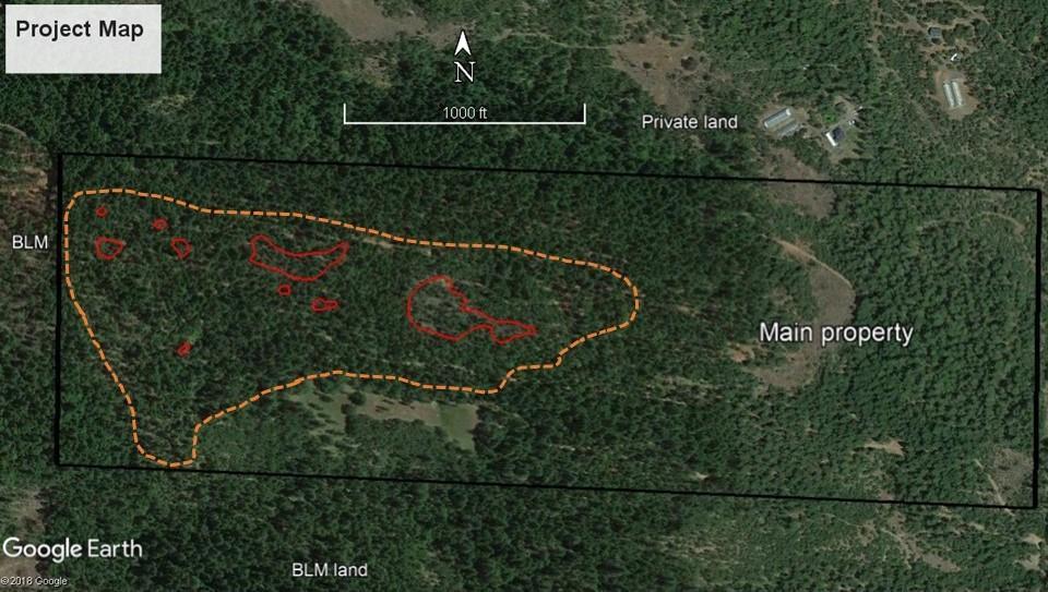
In May 2016, a 36-acre prescribed underburn was completed on the Marty and Peggy Main property near Trail, Oregon. The Main property is a 120-acre parcel consisting of low-elevation, dry, mixed conifer forest typical of the area. The owners’ land management objectives include:
- Promoting mature forest conditions and values
- Managing for multiple tree species and age classes
- Reducing the potential for high-severity wildfire
- Generating income from sales of logs and forest byproducts
An overarching goal is restoring ecosystem processes and returning the site to a more frequent, lower-severity disturbance regime (see Glossary).
Since acquiring the property in 1989, the Mains have carried out a number of noncommercial and commercial thinnings and two previous prescribed underburns. Management activities on the property are described in the OSU Extension publication Mixed Conifer and Hardwood Management in Southwest Oregon (EM 9084) https://catalog.extension.oregonstate.edu/em9084.
The burn project on the Main property is of interest in part because it was conducted on private lands adjacent to public lands managed by the Bureau of Land Management (BLM). A portion of the adjacent BLM parcel was also thinned and underburned. This type of coordinated approach across property lines is critical to implementing effective landscape-scale wildfire management strategies.
This publication briefly summarizes the planning, implementation, and results of the 2016 burn project on the Main property, as well as the lessons learned.
Planning and preparation
The prescribed burn was implemented only after many thinnings had reduced fuel loads. This included several noncommercial thinnings followed by a commercial thinning in a 36-acre stand. These were mainly thinnings from below, which increased crown base heights, reduced ladder fuels, and released desired overstory trees, making them more capable of withstanding fire-related impacts. Surface fuels, including thinning slash, were treated through aggressive utilization of thinned material (e.g., for poles, firewood) and occasional pile burning of heavier concentrations. Underburning was completed on 11 of the 36 acres about 20 years before the current operation. All these fuels-reduction treatments set the stage for the 2016 underburn.
The owner reached out to neighboring landowners, including the BLM, to promote joint efforts to reduce local fire hazards. This ultimately resulted in a memorandum of understanding with BLM under which the agency agreed to conduct the underburn to tie in with its own fire and fuels treatments along a cross-boundary strategic ridgeline.
The owner worked with BLM staff and other fire specialists to develop a comprehensive burn plan to meet owners’ objectives while achieving cross-boundary fire management benefits. Key objectives of the plan included:
- Reductions in surface and ladder fuels
- An overall reduction of the risk of high-severity fire
- Retention of minimum levels of duff and litter to protect soil values
- Retention of wildlife habitats, especially large, old black oak (Quercus kelloggii) trees
- Completing one more step in returning the site to a more frequent, low-severity disturbance regime with fire as an integral part of that process
Previous individual stem-mapping and stand-reconstruction work in adjacent older forests provided a historical template of forest spatial conditions used as a reference to guide implementation of forest management, including the prescribed underburn. Rather than try to specify the exact size and location of gaps to mimic the historical template, the owner chose to let fire produce its own random pattern, essentially encouraging the very process that historically produced structural diversity on both a stand and landscape level.
Existing roads were used as fire lines where feasible. Elsewhere, a fire line was dug by hand to tie in the perimeter of the burn unit to help define the desired edge of the fire.
Smoke management is a critical consideration in any prescribed fire. The burn plan called for ignition only when the ventilation index (see Glossary) and wind direction would facilitate adequate smoke dispersal, as determined by Oregon Department of Forestry (ODF) on the day of the burn.
The owner submitted a Notification of Operations to ODF and coordinated with ODF’s smoke-management division before ignition.
The burn was scheduled for late spring, prior to fire season. This timing allowed for sufficient drying of fuels after winter rains and good ventilation to disperse smoke but before the hotter, drier, and more explosive conditions of summer that would make burning extremely risky. Another potential “shoulder” season for prescribed burning occurs in the fall.
The BLM covered costs under its fuels-management program, so a cost per acre for this particular operation is difficult to determine and not necessarily representative. Costs of prescribed burning vary widely depending on the size of the burn unit, access, terrain, operational complexity, and risks. A rough range for comparable projects is from $300 to $700 per acre.
Implementation
An experienced, 12-person BLM crew conducted the burn on May 10, 2016. Temperature, relative humidity, winds, ventilation, fuel moisture, and fuel amounts were closely monitored before the burn to determine whether to proceed.
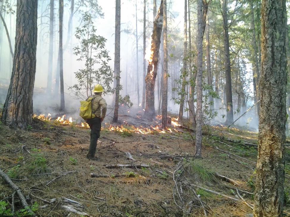
After a successful test fire, the burn was started at the highest point of the unit and progressed downslope in successive strips. That way, each strip would burn into an area that had already burned. This increased the “black line,” decreased the chance for escape, and controlled flame length and fire intensity.
Firefighters patrolled perimeter lines throughout the burn and during subsequent mop-up operations to ensure the fire stayed within the unit.
As site conditions, fuels, and weather changed during the day, ignition was modified as needed to keep the fire within desired rates of spread and intensities, minimize crown scorch (see Glossary), and reduce site impacts. For example, when it became apparent that fire behavior in some upper slope positions was on a trajectory to be more intense than desired, lighting intensity (i.e. strip-firing techniques) was reduced.
Results of the prescribed burn
Fuel loads were reduced. Overall reduction of 1-, 10- and 100-hour fuels (see Table 1) was reduced to 39 percent of preburn amounts (Table 2), with greater reduction in the portion of the area that had not previously been underburned and lesser amounts in the area that was underburned in 1993 (because fuels were already low in that location).
Ladder fuels were reduced. In the area underburned in 1993, woody fuel loads were low, but manzanita and madrone had grown back to a height of 1 to 5 feet, resulting in abundant ladder fuels. The 2016 burn killed an estimated 90 percent of the manzanita and top-killed a similar amount of the madrone, significantly reducing these ladder fuels .
Overall burn severity was low. Composite burn index (CBI, see Glossary), an estimate of increasing fire severity (see Glossary) on a scale of 0 to 3, was measured at 18 systematically located sample points. The average CBI value was 0.73, well within the range of values for low-severity fire (0.5 to 1.5).
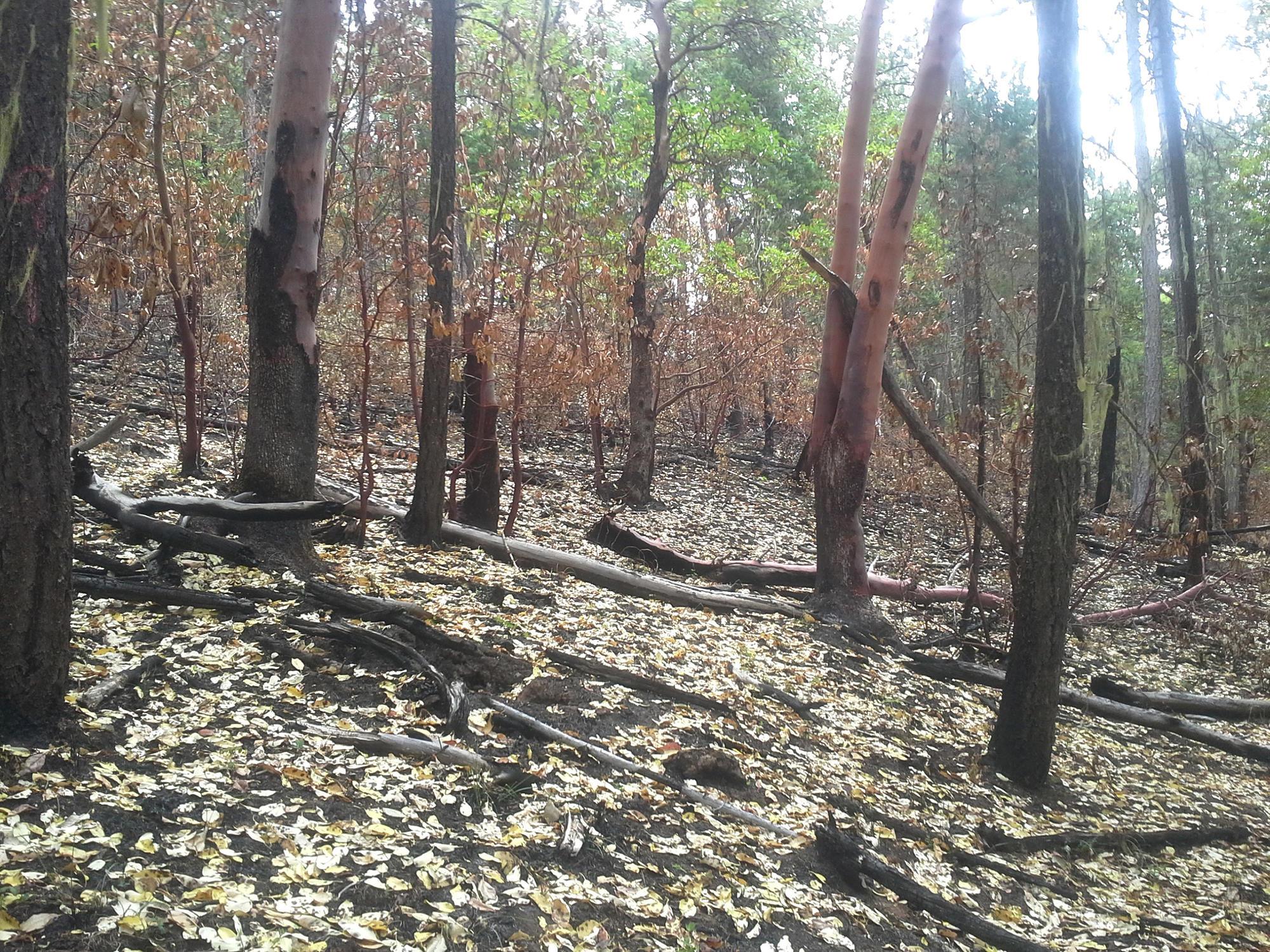
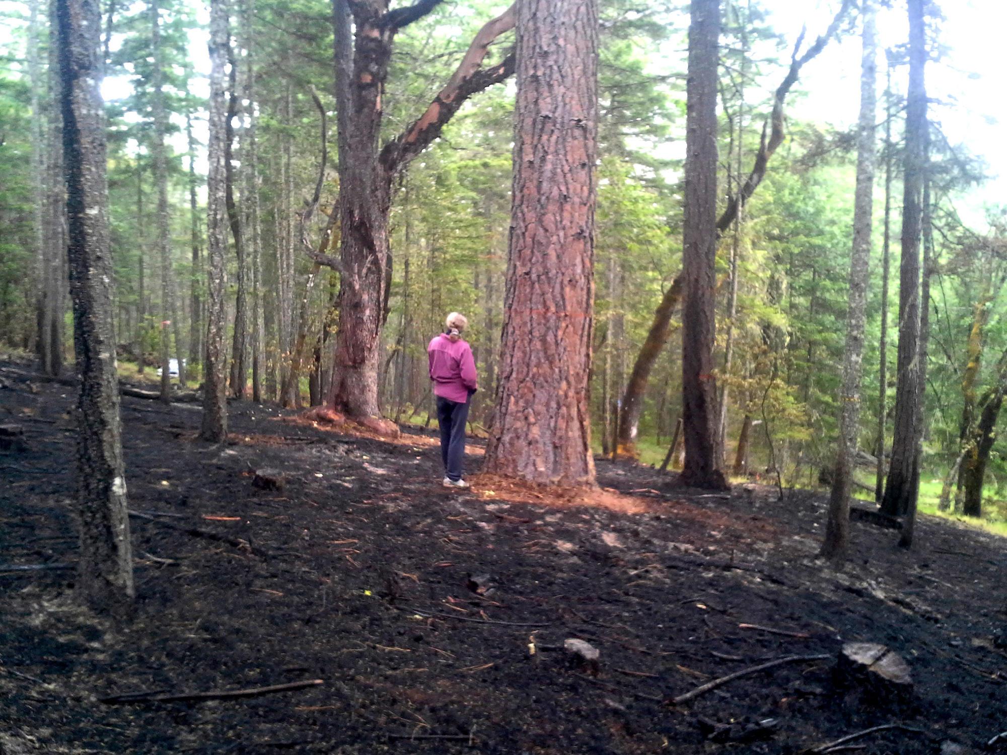
Burn intensity and effects were variable. Some areas didn’t burn at all, some burned very lightly, and others burned more intensively, creating a mosaic of postburn conditions. Previous thinning treatments had elevated the average height-to-crown base such that little crown scorch occurred in most areas. Greater fire severity was associated with a combination of the following factors: steeper slopes, upper-third slope positions, heavier surface-fuel loads, lower tree-crown base heights, and burning during mid-afternoon when it was warmer and drier.
There was patchy mortality. Patches of crown scorch and tree mortality, visible in a Google Earth image taken a few weeks after the burn, were mapped and validated in the field. These patches, where crown heating killed a portion of the overstory trees, comprised a total of about 2.5 acres in the 36-acre unit. Patches ranged in size from 0.02 up to 1.4 acres and contained a wide variation in overstory mortality, from a few trees up to a maximum of about ⅓ acre where all overstory trees were killed. As intended in the burn prescription, this created additional structural diversity in a relatively homogenous stand and occurred in a random pattern consistent with how fire typically interacts with fuels and vegetation.
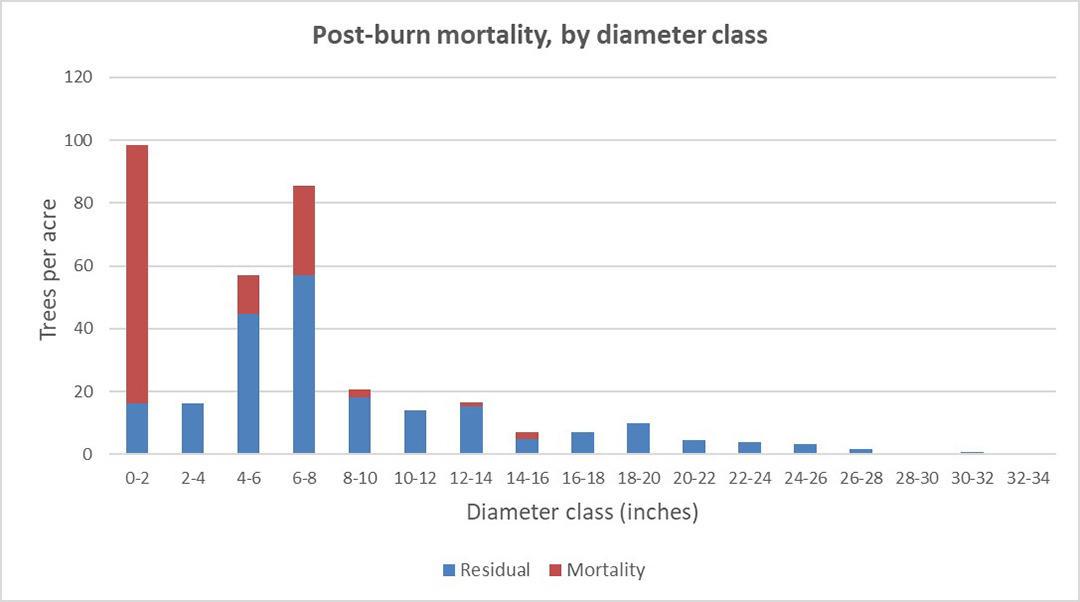
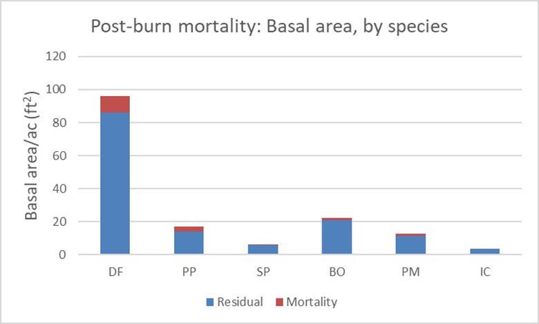
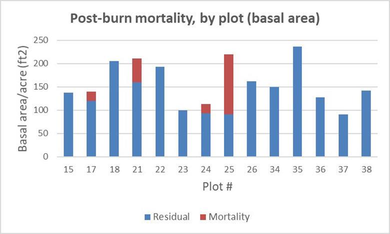
Mortality was greatest in the smaller size classes. Postburn monitoring of mortality in permanent plots systematically located throughout the burn unit showed that the underburn killed or heavily damaged 128 trees per acre, mostly in smaller size classes, which were dominated by Douglas-fir. Total stand basal area was reduced by 10 percent, from 158 square feet per acre (ft2/a) to 142 ft2/a. The greatest reduction in actual trees was Douglas-fir, with the greatest reduction in percentage terms in ponderosa pine. Of the 17 permanent plots, only three experienced mortality, but in one of the three plots, over 50 percent of the basal area was killed.
Large old black oaks did well. Within the 14 permanent plots only one large (12-inch diameter at breast height (DBH)) black oak was killed. Preburn raking away of litter and duff within 1 foot of the bole, fuel redistribution, water application to black oak boles on burn day, and careful ignition techniques helped minimize mortality and additional tree stress. We expected that the presence of many large, dead limbs extending into the bole would make ignition more likely from embers, and that fire would spread to the often punky heartwood, but for the most part this didn’t occur. As expected, the thin-barked madrone did not fare as well. By 2 years after the burn, several large madrone had been top-killed, presumably as a result of cambial damage from the fire.
Mixed results for ponderosa pine. Larger pine in the unit were also raked and most survived. Ponderosa pine mortality as a result of crown heating was confined to one plot where the fire was more intense. In addition, western pine beetles subsequently killed several pines in this plot and in the immediate vicinity, probably because the trees were damaged and additionally stressed by the fire, which made them more vulnerable to bark beetle attack. Similar-size Douglas-fir that experienced the same fire intensity (see Glossary) in the same area were not killed, perhaps because they didn’t have an associated bark beetle response.
Additional mortality was observed 2 years following the burn, primarily in Douglas-fir in the smaller size classes (<6” DBH). Most of these trees experienced a combination of crown scorch and basal heating, which may have damaged or killed the cambium, roots, or both just below the surface.
Natural regeneration of conifers was abundant but declined 2 years postburn. One year after the underburn, there were an estimated 3,963 germinants (i.e., conifer seedlings less than 1 year old) per acre, and 57 percent of the sampled plots had at least one germinant. Distribution was very patchy, with a few plots having large numbers of germinants, while most had few or none.
One year later, there were only 764 germinants per acre and 44 percent of the plots were stocked. The vast majority of the germinants observed in year two appeared to be from the current year, suggesting that few of the first-year germinants had survived over the summer. Although it was difficult to determine the species of germinants less than 1-year-old, we assumed most were Douglas-fir, given the abundance of this species in the overstory.
Adjacent stands were protected. In addition to improving landscape-level fire protection by tying into the thinning and burning treatments on the adjacent BLM parcel, the burn also provided protection for an older forest stand located on the adjacent north slope of the Main property.
Postburn treatments
Salvage
Slightly over one log-truckload of fire-killed, merchantable trees was salvaged and taken to a mill. This included trees killed outright by the fire as well as conifers damaged and likely to succumb in the ensuing year.
Several pickup loads of small poles were also removed for sale, and an estimated 5 to 10 cords of firewood will be generated from fire-killed, noncommercial trees in the unit. Nonmerchantable, beetle-infested pine and larger pines that had limited market value were piled and burned. A few fire-killed trees were left as snags for wildlife habitat.
Planting
In the winter following the fire, about 300 ponderosa and blister rust-resistant sugar pine seedlings were underplanted in canopy gaps created or accentuated by the prescribed burn. Establishing a new cohort of ponderosa pine was a high priority for the owners; they felt that natural regeneration of pine was unreliable and would probably be overwhelmed by the much more abundant naturally regenerating Douglas-fir.
Key findings and take-homes
The burn project was successful in meeting the key preburn objectives of substantial reduction of the potential for high-severity wildfire while protecting soil, water, wildlife, and timber resources. However, the burn was conducted only after completion of several previous thinnings and follow-up slash treatments that reduced fuels enough to create favorable stand conditions for a successful underburn.
Planning a burn project that would result in greater landscape-scale reduction in fuel hazard was critical to development of the memorandum of understanding with BLM. The value of this planning and subsequent implementation became much more obvious in August 2016 when the Cleveland Ridge wildfire burned to within a quarter mile of the property.
Prescribed underburning is a blunt instrument resulting in more random effects than would be achieved with more precise mechanical treatments. Such effects may include a mix of unburned patches with areas of crown scorch, overstory mortality, and variability in fuels consumption across the treated area. In terms of the ecological objectives for this project, these variable effects were desired. For example, having a few patches of crown scorch and dead trees will help achieve the owners’ goal of increasing the number and size of forest gaps, creating a more diverse stand structure in the long term and moving the stand closer to historical conditions that resulted from more frequent fire. The crown patchiness and more discontinuous crown fuels also reduced the likelihood of continuous crown fire in a wildfire.
The immediate visual impact of the burn was significant; the ground was black and many trees had scorch marks. Some trees were killed in small patches. While these effects were acceptable and desirable from the perspective of this owner, other owners may find the results too stark or severe. This was evident from the reactions of a few attendees at a postburn tour. However, these visual effects typically lessen over time, particularly as postburn vegetation vigorously responds (“greens up”).
The results suggest that preburn raking and other measures can help reduce stress to and mortality of desired trees—in this case ponderosa pine, sugar pine, and large, old California black oaks. The burn exposed abundant mineral soil and occurred in conjunction with a decent cone crop, resulting in significant but patchy conifer regeneration, primarily of Douglas-fir. Survival of newly germinated seedlings was very poor over the first summer, which was hotter and drier than average. Planting is a much more reliable route to regeneration, especially if a species composition change (e.g., to increase amounts of ponderosa and sugar pine) is desired.
The burn reduced stand density and fuel loads and introduced greater spatial variability in stand structure (e.g., small canopy gaps). The stand is now set up well for future prescribed underburns as part of the overall plan to promote older forest conditions on the parcel.
A system of permanent plots and pretreatment measurement of stand and vegetation conditions and fuel loading allowed burn effects to be quantified; this is time consuming but very helpful in documenting results.
Although no prescribed underburn is risk free, this project showed that with careful planning and execution, a successful burn can be carried out on a small private woodland. Key ingredients included a trained, qualified crew; oversight by an experienced burn boss; and adherence to a comprehensive burn plan.
Glossary
Composite burn index (CBI). CBI is a measure of burn severity relative to prefire conditions. It considers substrates, including soils, duff, litter, and downed woody material, as well as vegetation, ranging from herbs and low shrubs to overstory trees.
Crown scorch. Foliage in the crown of the tree that is killed by convective heat from the fire but is not consumed in the fire itself. The needles turn brown following the fire. This may take several weeks.
Disturbance regime. A disturbance is an event that causes a significant change in the structure or composition of a forest. Examples include fire, windstorms, and timber harvest. A disturbance regime is a typical set of disturbances that occurs in a forest over time. Frequent, low-severity wildfire is an example of a disturbance regime.
Fire intensity. Fire intensity is the amount of energy or heat given off by a forest fire at a specific point in time. (Source: NW Fire Science Consortium)
Fire severity. Fire severity refers to the effects of a fire on the environment, typically focusing on the loss of vegetation both above ground and below ground but also including soil impacts. (Source: NW Fire Science Consortium)
Prescribed underburning. A method that allows a fire to burn in a forest understory under designated conditions within a defined boundary.
Ventilation index. A numerical measure of the potential of the atmosphere to disperse smoke based on wind speeds, atmospheric instability, and mixing heights. Burning is generally only allowed when the ventilation index is high enough to adequately disperse smoke.
Considerations for prescribed underburning on private property
Prescribed burning, especially underburning, can be risky, with high potential liability.
It is critical to get advice from an experienced professional to assess risks and benefits before deciding to undertake a burn project.
A professionally developed burn plan is a must. A properly developed and executed burn plan reduces the risk of an escaped burn and reduces your liability. Key aspects of a burn plan include:
- A clear description of the stand or vegetation to be enhanced by underburning and expected outcomes for that vegetation
- Data on fuel amount, distribution, moisture content, topography, and desirable weather conditions on burn day
- Predictions of fire behavior and fire spread based on the above factors
- Ignition patterns and arrangements for holding (maintaining the fire within the desired area), and mop-up standards, if any
- Timing and season of the burn
- Smoke management guidelines
- Requirements for needed equipment and personnel
- Safety precautions, medical concerns, and other operational considerations such as communication. If the operation area is out of cell phone range, radio or radio/satellite phone communication may be required.
In addition to getting the assistance of a professional for developing a burn plan, scope out local contractors who are available to execute burns safely and professionally. These may be rare in any given operating area.
The cost per acre of prescribed burning can be relatively low on large acreages in remote areas, but by their very nature (small parcels, higher risk, high complexity) projects on small acreages can be much more expensive.
Contact your local and state fire-control agencies in advance to discuss your plans and obtain permits. Reach out to neighbors, local fire departments, and others affected by the underburn well ahead of the burn day.
It can be challenging to “put all the pieces together” for a successful prescribed burn. It is often a waiting game until fuels and weather come “into prescription.” A decision to conduct a burn should never be made until the morning of the burn.
Even before proceeding on burn day, a go/no go decision, followed by a test burn, may result in a final decision not to burn.
Table 1. Fuel categories (size) and their contribution to fire behavior
|
Fuel category |
Diameter (inches) |
Description |
Impact on fire behavior |
|
1-hour |
0.00–0.25 |
Needles, twigs, moss, lichens, small shrubs, and grasses |
Easily ignited. Support initial fire spread and the heating and combustion of larger fuels. Under dry conditions, these fuels are flashy and surface fires spread quickly. |
|
1-hour |
0.25–1.00 |
Small branches, shrubs |
Support fire spread and the heating and combustion of larger fuels. Under very dry conditions, fires spread quickly. |
|
100-hour |
1.00–3.00 |
Medium-sized branches |
Support fire spread and the heating and combustion of larger fuels. |
|
1,000-hour |
3.00–8.00 |
Large branches, small logs |
Support fire spread. Increases fire duration and influences fire severity, depending on the loading. |
|
10,000-hour |
>8.00 |
Large downed logs that are solid or moderately decayed |
Ignite after flaming front has passed. Large fuel pieces do not support fire spread but can increase fire duration and severity near the log. If fuel loading is high and distributed across the site (such as from beetle-killed trees), high fire severity can be more widespread and increase resistance to control and the duration of burning. |
|
Snags |
Variable |
Bole only or bole with large branches, depending on snag condition |
When snags combust, they can torch, lofting embers and firebrands ahead of the main fire, starting additional spot fires. Snags may increase resistance to control. |
Table 2. Fuel Loading, Preburn, and Postburn, Main property
|
Tons per acre |
||||||
|
1 hr |
10 hr |
100 hr |
fine total |
1,000 hr |
fuel total |
|
|
Preburn |
0.34 |
2.01 |
3.99 |
6.34 |
8.72 |
15.06 |
|
Postburn |
0.10 |
1.09 |
1.29 |
2.48 |
7.32 |
9.80 |
Resources
Bennett, M., S.A. Fitzgerald, M. Main. 2013. Management of a Mixed Conifer and Hardwood Forest in Southwestern Oregon. EM 9084. Oregon State University Extension Service. https://catalog.extension.oregonstate.edu/em9084
Bennett, M., S.A. Fitzgerald, R.T. Parker, C. Schnepf, M. Main, A. Perleberg, R. Mahoney. 2010. Reducing Fire Risk on Your Forestland Property. PNW 618. Oregon State University Extension Service. https://catalog.extension.oregonstate.edu/pnw618
Northwest Fire Science Consortium http://www.nwfirescience.org/ Excellent source of publications, fact sheets, videos, and other materials on prescribed fire, wildfire, and related topics.
Leavell, D., C. Berger, S.A. Fitzgerald, B. Parker. Fire Science Core Curriculum. EM 9172. This curriculum is designed to teach the basics of fire to non-fire-professional community members, including instructors, landowners, ranchers, and farmers. The goal is to reduce risk and fire hazard through education and understanding. https://catalog.extension.oregonstate.edu/em9172
Acknowledgements:
We thank Al Mason, Bureau of Land Management, Medford District, for his assistance in developing the burn project memorandum of understanding and for overseeing the burn operation. We thank Kara Baylog, OSU Extension, for her assistance in postburn monitoring.
© 2018 Oregon State University.
Extension work is a cooperative program of Oregon State University, the U.S. Department of Agriculture, and Oregon counties. Oregon State University Extension Service offers educational programs, activities, and materials without discrimination on the basis of race, color, national origin, religion, sex, gender identity (including gender expression), sexual orientation, disability, age, marital status, familial/parental status, income derived from a public assistance program, political beliefs, genetic information, veteran’s status, reprisal or retaliation for prior civil rights activity. (Not all prohibited bases apply to all programs.) Oregon State University Extension Service is an AA/EOE/Veterans/Disabled.
